Showing posts with label tourism. Show all posts

Saturday, July 28, 2018

“Seeing Is Not Enough”: World War I Battlefield Tourism

German Stahlhelm and postcard sent to
Louise and Bertha Trainer, 1921
After an unintentionally long hiatus, the Alice News blog is back with a story inspired by our recent exhibit of World War I artifacts at the Centennial Summer Fair. Most of the war relics in the Alice’s collection were obtained by servicemen who acquired them during their time overseas. However, one battered and rusty German helmet was given to Louise and Bertha Trainer by a friend of theirs who visited the battlefields of Belgium in 1921. Emma Kindl was one of thousands of tourists who made pilgrimages to sites in France and Belgium in the years after the Great War.

While we are accustomed to the idea of battlefield tourism today, we probably tend to associate it with the visiting of sites like Civil War battlefields—places where time has removed the most obvious evidence of their violent past. It may seem strange that people were interested in visiting trenches and ruined villages in the immediate aftermath of the war. But even before the armistice, commentators were predicting that there would be a boom in battlefield tourism. The war had been such a profound and life-altering event for so many people that it seemed inevitable that they would want to witness for themselves the places whose names had become part of their vocabulary: Ypres, Vimy, Passchendaele, Verdun.

Another factor encouraging travel was the decision not to return the bodies of the fallen to their home countries but to bury them on or near the battlefields. Bereaved family members had to travel in order to visit the graves of their loved ones. World War I also produced an extraordinarily large number of bodies that were never identified or otherwise remained unaccounted for. For the families of these missing men, a trip to a battlefield or war memorial was the closest they would come to visiting their final resting place. 

From the Michelin Guide
Ypres and the Battle of Ypres (1919)
Widows, parents, and children did not think of themselves as battlefield tourists but as pilgrims, visiting hallowed ground. Nevertheless, they frequently required guidance to locate the sites they wanted to visit, and a variety of charitable organizations were established in the post-war years to assist families and ex-servicemen. Travel agencies like Thomas Cook offered organized tours of sites associated with the war in France, Belgium, Italy, and the Middle East, and Michelin issued its first battlefield guidebooks in 1919. Volume I of this series, The First Battle of the Marne, stated quite explicitly, “The contemplated visit should be a pilgrimage; not merely a journey across the ravished land. Seeing is not enough, the visitor must understand; ruins are more impressive when coupled with a knowledge of their origin and destruction.”

From the Michelin Guide
Lille Before and During the War (1919)
The Michelin guides (31 titles in French and 15 in English) all followed a similar pattern. They began with an overview of the battles covered in the guide (“a clear comprehension of the action as a whole is absolutely necessary to a full understanding of the separate engagements”), after which itineraries were laid out. These itineraries were, in some ways, not all that different than those in ordinary guidebooks, including driving directions, histories of towns and villages, and information about churches and other landmarks. But they were also detailed accounts of battles, bombings, and wartime deprivation, often including first-hand accounts from those who had experienced them. The books were lavishly illustrated with photographs, many of them before-and-after views which highlighted the destruction wrought upon the landscape. Using the Michelin guides, the visitor could retrace the daily—almost hourly—progression of the war.

The idea that one could recreate the experiences of the past through visiting the battlefields seems to have been an important one both for families and for ex-servicemen. For the bereaved, retracing the steps of their loved ones helped them feel closer to those they had lost. The journey to the grave or battlefield was an essential part of the grieving process for many people, allowing them a venue to confront their emotions and emerge afterwards in a more hopeful and accepting frame of mind. Some ex-servicemen found revisiting battlefields therapeutic as well. By reliving their pasts and facing their memories, they could come to terms with the effects of the war.

Postcard of the battlefield at Kemmel. A note on the back states that
this field is where Mlle. Kindl picked up the helmet.
Of course, over time, the landscape of the battlefields changed, and it became harder to relive the past. In the early 1920s, the destruction of the war was still very clear. As one guidebook put it, “The ruined villages are as the shells and bombs left them. Everywhere are branchless trees and stumps, shell craters roughly filled in, trenches, barbed wire entanglements, and shelters for men and ammunition. Thousands of shells, shell casings, rifles, gun-limbers, and machine-guns lie scattered about.” Some battlefields and trenches were preserved in their wartime state, either by commercial operators or by Dominion governments (for example, the Canadian government was instrumental in preserving portions of Vimy Ridge), but for the most part, nature and agriculture reclaimed the fields. In this context, souvenirs took on great significance. Locating and bringing home a tangible reminder of the battlefield became even more important as time passed and the material effects of the war were less obvious.

Sources:

This post is primarily drawn from the David W. Lloyd, Battlefield Tourism: Pilgrimage and the Commemoration of the Great War in Britain, Australia, and Canada, 1919-1939 (Berg, 1998). Other sources on battlefield tourism include Brian Murphy, “Dark Tourism and the Michelin World War I Battlefield Guides,” Journal of Franco-Irish Studies v. 4 (2015) and Caroline Winter, “Tourism, Social Memory, and the Great War,” Annals of Tourism Research v. 36 no. 4 (October 2009). An excellent source on monuments and the memory of World War I more broadly is Jay Winter, Sites of Memory, Sites of Mourning: The Great War in European Cultural History (Cambridge University Press, 1995).

Thursday, January 25, 2018

The Spanish Colonial in San Diego—and Chazy

Chazy Central Rural School, 1919
The Chazy Central Rural School building which stood from 1916 until 1969 was unusual in many ways. Most rural schools (or urban schools, for that matter) did not have swimming pools, film projectors, or marble-topped cafeteria tables. Also unusual was the choice of architectural style: a blending of Mission and Spanish Colonial elements. Why did William H. Miner and his architect, Frederick Townsend, choose this style—associated with the American Southwest and Mexico—for a school building in the far north of New York State?

Neither Townsend nor Miner seem to have left any definitive statement on the matter, so we’ll probably never know for sure, but one influence may have been the 1915 Panama-California Exposition in San Diego. The Panama-California Exposition was one of two world’s fairs held that year to celebrate the completion of the Panama Canal. The other, in San Francisco, was much larger, but San Diego found ways to differentiate its exposition from its northern neighbor.


Promotional pamphlet made by the
San Diego Board of Supervisors
At the time of the fair, San Diego had a population of about 40,000, making it the smallest city ever to host a world’s fair. But city boosters saw this as an opportunity to shape San Diego’s public image and attract future residents, investors, and tourists. The exposition’s architecture and landscape design would demonstrate that the city and region had a rich history, while the exhibits would show that it was forward-thinking in technology, industry, and agriculture. Perhaps the city’s biggest selling point was its climate: this would, it was proudly announced, be the first “All-the-year-round” exposition. As one promotional pamphlet exclaimed, “Nowhere else but in this land of favored climatic conditions could such a fair be possible. Here is perpetual Springtime. Here is a climate that couldn’t be more delightful if it were made to order.” By opening the fair on January 1, organizers made the most of the contrast between winters in Southern California and other parts of the country.

The Varied Industries building and gardens
Floods of promotional material about the San Diego fair began to appear several years before it opened, as organizers, the city’s chamber of commerce, and railroads began to drum up interest. Naturally, much of their focus was on the new buildings being constructed in Balboa Park beginning in the summer of 1912. Unlike most world’s fair structures, a number of these were always intended to be permanent additions to the site—and indeed the whole complex proved to be so beloved by the local community that others were also kept and re-used for other purposes, including another fair in 1936. Instead of the classically-inspired architecture that had become the standard at previous fairs, organizers chose the Spanish Colonial as a distinctive and versatile style. The unified design scheme, along with the strong historical and regional associations of the style, would help San Diego’s fair distinguish itself from San Francisco. For many Americans living in the northeast and midwest, this was probably their first real exposure to Spanish Colonial and Mission architecture, and the San Diego fair led to a surge in its popularity. 


Originally the Indian Arts Building,
rebuilt in 1996 and now home to the
San Diego Art Institute
The fair’s Director of Works, Frank P. Allen, Jr., wrote that the Spanish Colonial was an ideal choice for exposition architecture not just because it was regionally appropriate but because it encompassed a wide range of styles, from “the ornate and whimsical extravagance of of Churriguersque and Plateresque, down to the simple lines and plain surfaces of the California mission buildings.” While being unified in material and inspiration, the buildings would also show an interesting variety. Art critic and curator Christian Brinton, writing in The International Studio, praised the fair’s buildings as “a distinct step forward in American architecture. Architects who have visited the grounds are enthusiastic over the genuine renaissance of the glories of Spanish art and architecture which they feel will follow the San Diego Exposition.”

Visitors and critics alike agreed that the Exposition’s vision of “Old Spain” in California was a success. However, it also raised some questions about the uneasy place that the Spanish and Native Americans occupied in Anglo Americans’ conception of national history. It was generally acknowledged that the unique qualities of Spanish Colonial architecture came from the combination of Spanish design with Native American materials and labor. This was something to be proud of, something that set the buildings of the Americas apart from their European counterparts. At the same time, most writing about the fair also produced the clear impression that Spanish and native contributions were part of the past. Exhibit material stated in no uncertain terms that while there once had been great indigenous civilizations in Mesoamerica, the great days of the Maya were long past by the time the Spanish arrived. Present-day Indians were described as “living just as they have lived and their ancestors have lived for centuries.” 


Zuni women making pottery as part of the
“Painted Desert” exhibit
Similarly, while the Spanish were given credit for starting the process of Christianizing and “civilizing” the southwest, it was also made clear that Anglo-Americans were now taking on that mantle—bear in mind that since 1898, the United States had also acquired many of Spain’s former colonies. Early 20th-century racial and evolutionary theories presented this sequence of events as inevitable: just as Native Americans had been conquered by the superior Spanish, so too were the Spanish ultimately supplanted by the superior Anglo-Americans. Adopting the Spanish Colonial style (and, it was strongly implied, improving it) was a way to symbolize this transition.


CCRS under construction, 1916
For William Miner and Frederick Townsend, the Spanish Colonial may have seemed like a good choice for Chazy Central Rural School because it was both traditional and up-to-date. It would certainly have stood out as something unique among the other buildings in the village, making clear that this school was different from the old rural school in every possible way. It also could be constructed with modern building materials, such as hollow brick and cement. Although the original school building did not stand for as long as Miner probably anticipated it would, it seems safe to say that it made an impression on everyone who saw it, and it is still fondly remembered today. 

You can still visit many of the Panama-California Exposition’s original buildings in Balboa Park, as well as others that were rebuilt in the 1990s.

Sources:

Panama-California Exposition Digital Archive

Frank P. Allen, Jr., “San Diego Exposition: Development of Spanish Colonial Architecture,” Fine Arts Journal 32, no. 3 (March 1915), 116-126.

Christine Edstrom O’Hara, “The Panama-California Exposition, San Diego, 1915: The Olmstead Brothers’ Ecological Park Typology,” Journal of the Society of Architectural Historians 70, no. 1 (March 2011), 64-81.

Hal K. Rothman, “Selling the Meaning of Place: Entrepreneurship, Tourism, and Community Transformation in the Twentieth-Century American West,” Pacific Historical Review 65, no. 4 (November 1996), 525-557.

Christopher Schmidt-Nowara, “Spanish Origins of American Empire: Hispanism, History, and Commemoration, 1898-1915,” The International History Review 30, no. 1 (March 2008), 32-51.

Abigail A. Van Slyck, “Mañana, Mañana: Racial Stereotypes and the Anglo Rediscovery of the Southwest’s Vernacular Architecture, 1890-1920,” Perspectives in Vernacular Architecture 5 (1995), 95-108.
SaveSave

Tuesday, November 18, 2014

New York State History Month: A Pilgrimage to Niagara Falls

The final stop on our trip through New York on transferware brings us to the western part of the state. These pieces from the Alice’s collection feature two great marvels of the early 19th century: the Erie Canal, a man-made technological triumph, and Niagara Falls, a natural wonder of sublime beauty. It was the completion of the Erie Canal in 1825 that for the first time allowed large numbers of Americans to visit the Falls, and made Niagara the premier tourist attraction of the age.

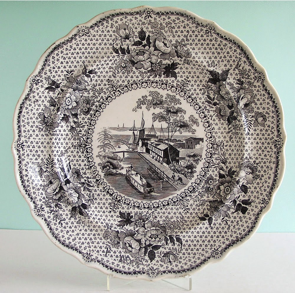
Ralph Stevenson, Erie Canal at Buffalo
 This plate, manufactured by Ralph Stevenson between 1830 and 1840, is one of many ceramic items produced in the 1820s and 1830s featuring towns and other scenes along the Erie Canal. This one depicts the canal’s end at Buffalo, showing both canal boats and sailing ships on Lake Erie. 

By connecting the Hudson River to the Great Lakes, the Erie Canal revolutionized the transportation of goods and people. American farmers had started exporting food crops to Europe on a large scale during the French Revolutionary and Napoleonic Wars (1793-1815). However, even as international exports increased, it remained very expensive to transport goods within the United States. In 1816, $9 could move one ton of goods across the Atlantic, but only 30 miles across land. The construction of the Erie Canal, which began in 1817 and launched a canal-building boom, would change all that. Now farmers who had previously grown crops for their own families began growing for the market. They earned cash and purchased goods they had previously made themselves—or gone without. 

Canals were accompanied by other improvements in transportation—the continuing development of steamboats, new roads offering swift stagecoach service, and, by the 1830s, railroads. New York City, as the port of entry to the Hudson River, secured its position as the largest and most economically important city in the nation. The flourishing steamboat industry turned St. Louis and Cincinnati into centers of trade, and Chicago would ultimately become the railroad hub of the Great Lakes region.

Map of the Niagara region from
The Northern Traveller, 1831
The revolution in transportation made tourism possible. The development of urban commercial centers created a population of prosperous middle-class Americans with the means to travel. Tourists could travel with relative comfort and safety, and there was a growing body of travel literature that told people how to be tourists and what they should look for. For most of the first half of the 19th century, Niagara Falls was the place to go. Indeed, it took on an almost sacred status, with some visitors referring to themselves as “pilgrims.”

Travel to Niagara from places outside Canada had been difficult through most of the 18th century, because it involved crossing through the territory of the Iroquois Six Nations Confederacy. In the early 1800s, there was not much in the way of accommodation for those travelers who did make it—just a small village at Lewiston, with slightly more on the Canadian side. The disruptions of the War of 1812 also hindered growth in the area. 

The first tourist guidebook
published in the U.S.
However, the War of 1812 also decisively settled the boundary between the United States and Canada, which allowed for rapid expansion of trade. The powerful Indian nations of the region were displaced, and emigrants, businessmen, and tourists began to flood westward.  Even before construction began on the Erie Canal, there were enough travelers along the route between Albany and Buffalo to create an infrastructure of roads, stagecoach routes, and inns. And indeed, long before the canal was complete, its construction led to huge improvements along the route, as roads, bridges, and ferries were needed to transport workers and supplies.

The development of Niagara as a tourist destination was also closely linked to the Hudson Valley. As noted in my previous post, the Hudson Valley became a tourist spot in the 1810s. As travel and facilities in the valley improved, access to destinations beyond the valley improved as well. The Hudson Valley, Saratoga Springs, the Erie Canal, Niagara, Montreal, Quebec, and Boston all became linked in a standard tourist itinerary known as the “Fashionable Tour.”

Enoch Wood, Niagara from the American Side
Niagara’s first genteel tourist hotel, built by William Forsyth, opened in 1822. Within a decade, Niagara Falls had become such a common destination among tourists that it was already something of a cliché. Visitors came to the falls already having seen and read countless depictions and descriptions of them—perhaps on a piece of transferware like this platter made by Enoch Wood. They knew they were supposed to feel overwhelmed by the grandeur of the experience, but many found themselves disappointed by the reality. Besides, it was hard to appreciate nature with so many other tourists around, not to mention the souvenir-sellers, entertainers, tour guides, and hucksters of
Niagara Falls from under the Table Rock
John Hill after William James Bennett, 1829-30
various types that surrounded the falls.


Still, many visitors did find that Niagara lived up to, or even surpassed, their expectations. The English writer Frances Trollope, who was highly critical of the United States in Domestic Manners of the Americans (1832), had only praise for Niagara Falls:

“Wonder, terror, and delight completely overwhelmed me. I wept with a strange mixture of pleasure and pain, and certainly was, for a time, too violently affected in the physique to be capable of much pleasure; but when this emotion of the senses subsided, and I had recovered some degree of composure, my enjoyment was very great indeed. To say that I was not disappointed is but a weak expression to convey the surprise and astonishment which this long dreamed of scene produced.”

Two excellent sources on the history of early American tourism are John F. Sears, Sacred Places: American Tourist Attractions in the Nineteenth Century (Oxford University Press, 1989) and Richard H. Gassan, The Birth of American Tourism: New York, the Hudson Valley, and American Culture, 1790-1830 (University of Massachusetts Press, 2008)

If you’re interested in the later history of Niagara Falls as a tourist destination, check out Karen Dubinsky, The Second Greatest Disappointment: Honeymooning and Tourism at Niagara Falls (Rutgers University Press, 1999).

Much more on the Erie Canal can be found at eriecanal.org